Thermomap
Description
The innovative project "ThermoMap" ("Area mapping of superficial geothermic resources by soil and groundwater data") was co-funded by the European Commission and aimed to map the very Shallow Geothermal Potential ("vSGP") to a maximum depth of 10 meters across Europe. This project's primary objective was to cultivate an environment for the development of modest geothermal systems across Europe.
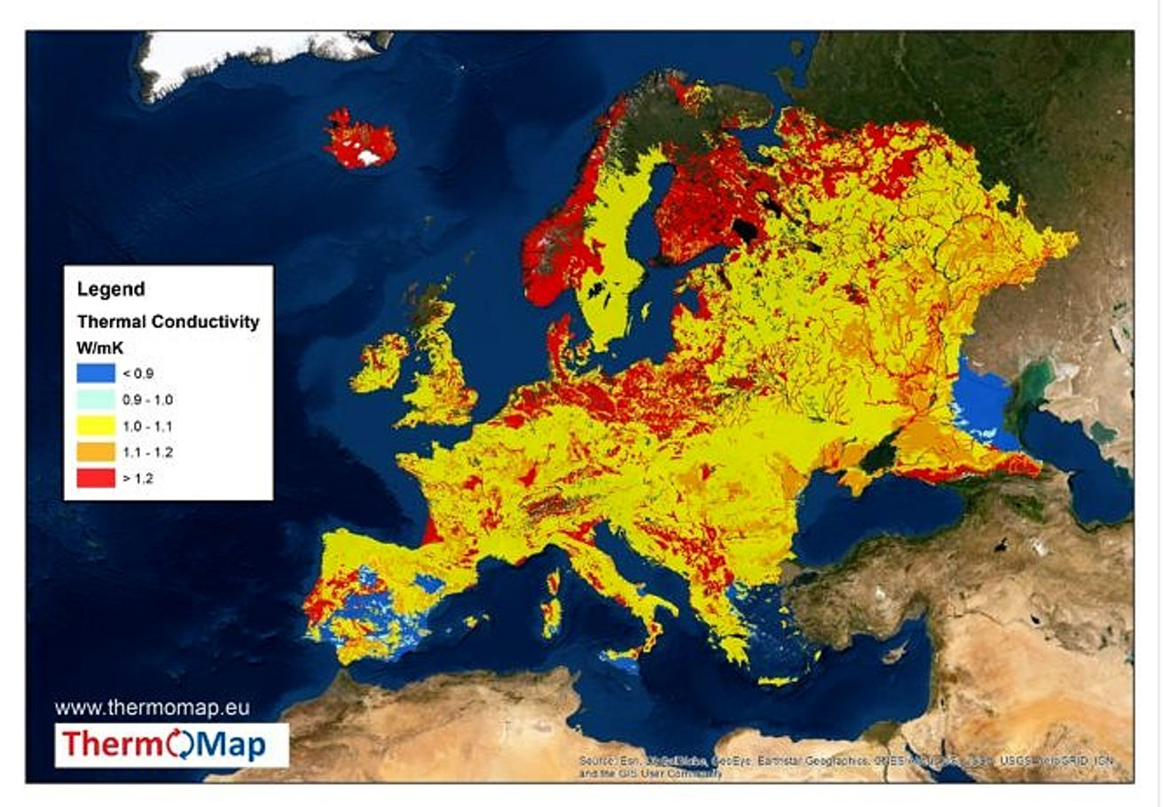
The ThermoMap project has collected, combined, harmonized, and analyzed pre-existing data sets (geological, hydrogeological, soil, climate, and relief data) in order to calculate a value for the shallow geothermal potential, defined as the thermal conductivity and/or heat capacity of unconsolidated ground at depths between 0 and 10 meters. The analysis and processing of these geodata were conducted in a GIS-environment using standardized, partner-applicable methodologies. In this initiative, twelve collaborators from nine European countries collaborated. The utilization of extant geoscientific data sets and their GIS processing can aid in the rapid, cost-effective, and dependable identification of favorable areas for shallow geothermal exploitation using Geothermal Heat Pump Systems. In addition to integrating the estimated geothermal potential values into an open source WebGIS, the estimated geothermal potential values also provided the background parameters used for mapping.
Users (companies, public authorities, designers, engineers, scientists, researchers, investors, homebuilders, individuals, etc.) can access the vSGP at a particular location. The ThermoMap project has created two extremely useful applications: a WebGIS application (MapViewer) and a Calculator. The ThermoMap Viewer is a specialized WebGIS service, i.e. an interactive map, that displays the vSGP across Europe and provides an overview and additional information about the local geothermal potential. The European Outline Map (EOM) provides a first estimate of the thermal conductivity of Europe's shallowest zone at a scale of 1:250,000 at the European level.

Gallery
Classifications
Scale of implementation
The platform covers multiple countries across Europe, providing information on national and regional regulations for renewable energy projects.
Type
Thermomap is a web-based platform that estimates and calculates the vSGP in terms of Heat conductivity of unconsolidated underground up to 10m depth.
Phase of solution
The aim of the ThermoMap project is to create pan-European geothermal potential maps as a supportive planning tool for geothermal installations up to 10m depth, in order to facilitate finding favourable areas for very shallow geothermal exploitation. This decentralized renewable energy source is an important complement to the already well researched energy sectors (wind power, solar energy, deep geothermal energy…) to help saving electricity, money and resources.
Target audience
Thermomap aims to provide comprehensive and scalable information on the geothermal potential, providing an overview and first estimation of maps for end users and stakeholders, as well as comprehensive background parameters for experts, planners, and researchers. The maps will cater to the needs of end users and stakeholders, while the specific location-based information will serve the requirements of experts, planners, and researchers.
Key features-functionality
The Thermomap system possesses several notable characteristics and capabilities, which are as follows:
- The Country Profiles offer in-depth analyses of European nations, furnishing extensive data on the regulatory frameworks, support mechanisms, and administrative protocols pertaining to renewable energy.
- Utilization of Interactive Tools: The implementation of interactive tools to facilitate the evaluation of local geothermal potentials by users. In order to accomplish this objective, the ThermoMap collaboration has gathered and standardized pertinent data, as well as devised methodology for the computation of heat conductivity and capacity.