Global Wind Atlas
Description
The Global Wind Atlas is a free, web-based tool designed to assist decision-makers, planners, and investors locate high-wind regions for the production of wind energy almost anywhere in the globe and then carry out first calculations. Based on the most recent input data and modeling techniques, the Global Wind Atlas supports online inquiries and offers freely accessible datasets. In the obtain section, users may also obtain high-resolution maps showing the potential for wind resources at the global, national, and first-administrative unit (State/Province/Etc.) levels for use in GIS applications. The technique and Datasets sections include information on the datasets and technique used to produce the Global Wind Atlas.
The Department of Wind Energy at the Technical University of Denmark (DTU Wind Energy) and the World Bank Group (comprising of The World Bank and the International Finance Corporation, or IFC) collaborated to create the most recent edition of the Global Wind Atlas (GWA 3.3). The Energy Sector Management Assistance Program (ESMAP), a multi-donor trust fund run by The World Bank and sponsored by 13 official bilateral donors, provided the bulk of the funding for the development of GWA 2.0 and GWA 3.0. It is a component of the international ESMAP project on mapping renewable energy resources, which also covers biomass, microhydropower, solar, and wind energy. DTU Wind Energy has a standing commitment to educating the world community about wind resources, and GWA 3.0 expands on that commitment.
This initiative has played a crucial role in promoting the transition towards a sustainable energy future. It facilitates data-driven decision-making and supports policymakers, businesses, project developers, and researchers in identifying suitable locations for renewable energy projects. Furthermore, the Global Atlas encourages collaboration and knowledge sharing among stakeholders, fostering innovation and advancements in renewable energy technologies.
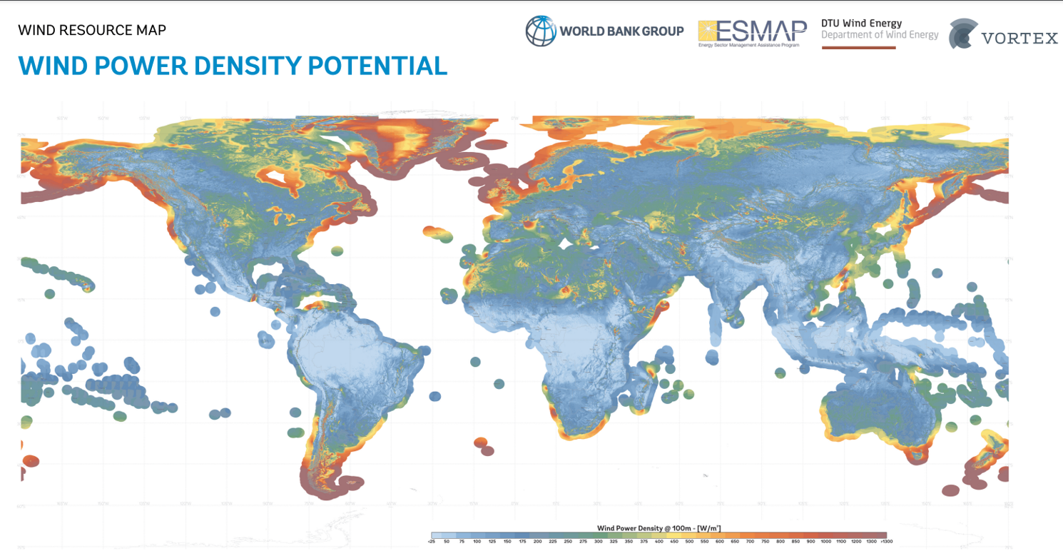
Gallery

Classifications
Scale of implementation
The Global Atlas is designed to be utilized at a global scale. It provides data and resources for assessing wind power generation areas in various countries and regions around the world. It caters to both individual users and organizations, including policymakers, researchers, businesses, and investors.
Type
The Global Wind Atlas is a web-based platform accessible through a web browser. It operates as an online tool and resource hub for wind energy data and information.
Phase of solution
The Global Atlas primarily operates in the pre-deployment and planning phase of renewable energy projects. It supports users in evaluating the renewable energy potential of specific locations, identifying suitable technologies, and facilitating informed decision-making during the early stages of project development.
Target audience
The Global Wind Atlas targets policymakers, government agencies, researchers, project developers, investors, and businesses engaged in -wind and- renewable energy. It serves as a valuable resource, offering them data, tools, and resources for assessing wind energy potential, formulating policies, planning projects, and making informed investment decisions.
Key features-functionality
The Global Wind Atlas offers a range of key features and functionalities that support the assessment and exploration of renewable energy potential worldwide. Some of the key features and functionalities include:
- Interactive Mapping Tools: The platform offers interactive mapping tools that allow policymakers, planners, and investors identify high-wind areas for wind power generation virtually anywhere in the world. Users can explore different layers of information, overlay multiple datasets, and customize the visualization to gain insights into the renewable energy potential of specific areas.
- The Global Wind Atlas assists investors and decision-makers with their early estimations. The wind resource may be evaluated at a specific location, over a specific region, or within a nation or first administrative entity (state, province, etc.).By year, month, and hour, users may evaluate the wind resource's fluctuation.
- Users may download high-resolution maps of the world, individual countries, and first administrative units from the Global Wind Atlas .With the help of the map-making tool, customized capacity factor, mean wind power density, mean wind speed, orographic, and roughness length maps may be created instantly and instantly in PDF format.
- Global Network and Community: The Global Atlas facilitates networking and collaboration through its global community of stakeholders.
- The Global Wind Atlas is validated: Data from ESMAP-funded measurement projects and other publicly available, high-quality wind data are used in the continuing validation process. Data from World Bank measurement initiatives carried out by ESMAP in Pakistan, Papua New Guinea, Vietnam, and Zambia are now being used for validation.
References & Sources for Further Reading
- Global Wind Atlas https://globalwindatlas.info/en/
- Badger, J., Hahmann, A., Larsén, X. G., Badger, M., Kelly, M., Olsen, B. T., & Mortensen, N. G. (2015). The Global Wind Atlas: An EUDP project carried out by DTU Wind Energy